
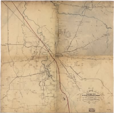
Stones River, Battle of›Topographical sketch of the environs of Murfreesboro, Tennessee. Surveyed Jan. 1863 under the direction of Capt. N. Michler, U.S.A., Chief Topl. Engr., Army of the Cumberland, by Maj. John E. Weyss, assisted by Captains: W. S
- Publication:
- US, Civil War Maps, 1861-1865
- Region:
- Tennessee
- Location:
- Stones River, Battle of
- Title:
- Topographical sketch of the environs of Murfreesboro, Tennessee. Surveyed Jan. 1863 under the direction of Capt. N. Michler, U.S.A., Chief Topl. Engr., Army of the Cumberland, by Maj. John E. Weyss, assisted by Captains: W. S
- Source:
- Library of Congress Geography and Map Division Washington
- Description:
- Surveyed Jan. 1863 under the direction of Capt. N. Michler, U.S.A., Chief Topl. Engr., Army of the Cumberland, by Maj. John E. Weyss
- Conflict Period:
- US Civil War
View the actual high resolution document.
About US, Civil War Maps, 1861-1865
Maps, charts, and atlases depicting battles, troop positions and movements, engagements, and fortifications during the Civil War, 1861-1865.
Source Information
Forces War Records, US, Civil War Maps, 1861-1865 (https://uk.forceswarrecords.com/document/260559894/topographical-sketch-of-the-environs-of-murfreesboro-tennessee-surveyed-jan-1863-under-the-direction : accessed 5 May 2024), database and images, https://uk.forceswarrecords.com/document/260559894/topographical-sketch-of-the-environs-of-murfreesboro-tennessee-surveyed-jan-1863-under-the-direction
- Publication Title
- US, Civil War Maps, 1861-1865
- Total Records
- 1,933Complete: 100%
- Content Source
Fold3
- Published on Forces War Records
- 20 May 2010
- Last Updated
- 18 November 2011
Related Records
Related Publications
- US, The Horse Soldier Civil War Collection of Military Artifacts, 1861-1865
- Civil War Stories
- US, General Court Martial of Gen. George A. Custer, 1867
- US, Subject File of the Confederate States Navy, 1861-1865
- US, Official Records of the Union and Confederate Navies, 1861-1865
- US, Maine, Burial Records of the Togus National Home for Disabled Veterans, 1874-1938
- US, Weekly Returns of Enlistments at Naval Rendezvous ("Enlistment Rendezvous") Jan. 6, 1855-Aug. 8, 1891
- US, New Hampshire, Revolutionary War Records, 1675-1835
- US, Washington State Military Records, 1855-1950
- US, Adjutant General Military Records, 1631-1976
- See all publications